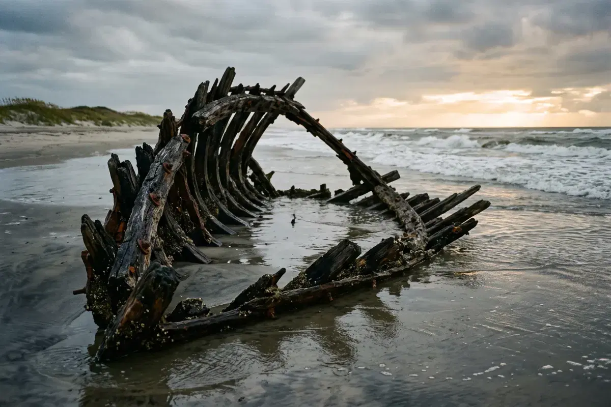
Stand on a beach in Kill Devil Hills at dead low tide on a calm morning and you may notice something dark breaking the surface a hundred yards out. It looks like a rock. There are no rocks on the Outer Banks. It is a ship's boiler, and it has been sitting there since 1927.
The water off this coast has been called the Graveyard of the Atlantic for well over a century, and unlike most tourist-brochure nicknames, this one is understated. It is one of the densest concentrations of shipwrecks on earth. Here is why it happened, what you can actually go see, and the part that matters most — the people who kept running into the surf after the ships.
What makes this water so dangerous
Two things converge off Cape Hatteras, and both of them are bad news for a sailing ship.
The first is current. The warm Gulf Stream runs north up the coast and meets the cold Labrador Current pushing south, and they collide right at the cape. The turbulence where they meet generates fog, sudden violent weather, and confused seas that can build with almost no warning.
The second is sand. Diamond Shoals is a system of three enormous sandbars, broken by shifting channels, that reaches roughly fourteen miles southeast off Cape Hatteras into open ocean. In places it is only a few feet deep. It also moves. A chart drawn one decade could be dangerously wrong the next, and for most of the age of sail there was no reliable way to know where the bars had gone.
So the Outer Banks sits at the exact point where the East Coast's main shipping route has to swing wide around an invisible, migrating, fourteen-mile sandbar — in fog, in current, frequently in a gale. Cut the corner too close and you ran out of water under the keel. Stand too far off and you lost the favorable current and the day's progress. Captains took the risk, and thousands of them lost.
How many ships are down there
Honest answer: nobody knows, and you should be suspicious of anyone who gives you a confident figure.
The most commonly repeated claim is more than 5,000 vessels lost since recordkeeping began in 1526. Estimates based on modern survey equipment and archaeological records put the number of identified wreck sites closer to 2,000. Diamond Shoals alone is credited with up to 600.
The range tells you something real. For most of that history, a small coastal schooner going down with four hands aboard did not necessarily generate a record that survived. The big number counts the losses people remembered; the smaller one counts the hulls that have actually been found.
The wrecks you can see without a boat
Most of the Graveyard is far offshore and deep. But the surf zone here is shallow and the sand is always moving, which means a handful of wrecks sit close enough to walk to, snorkel over, or in one case stand next to on dry sand.
Laura A. Barnes — Coquina Beach, Bodie Island. The easiest one by a wide margin, because it is on land. A four-masted schooner that came ashore in heavy fog on June 1, 1921. The crew all survived. The skeletal timbers were moved about a mile north by the National Park Service in 1983 and now sit in the dunes at Coquina Beach with an interpretive sign, a short walk from the parking lot. Sand covers and uncovers it year to year. Pair it with the Bodie Island Lighthouse just up the road — our guide to the OBX lighthouses covers all four.
Triangle Wrecks — Kill Devil Hills, Milepost 7. The boiler mentioned at the top. Two ships in one pile: the American tanker Kyzikes, lost December 1, 1927, and the Swedish freighter Carl Gerhard, which ran ashore on September 23, 1929 and struck the Kyzikes wreckage hard enough to cut it in two. The remains lie between roughly 100 and 250 yards off the Second Street beach access in 15 to 20 feet of water. At low tide on a calm day, the top of the Kyzikes stern and her boilers sit within inches of the surface.
USS Huron — Nags Head, near the Bladen Street access. The most historically significant wreck you can swim to, about 200 yards out in roughly 20 feet of water, usually buoyed in summer. In 1991 North Carolina designated it the state's first Historic Shipwreck Preserve. More on why below.
The Oriental — Pea Island. A Civil War-era steamer roughly three miles south of the Basnight Bridge over Oregon Inlet, across from the Pea Island visitor center. Her steam engine protrudes above the water about 100 yards offshore, which makes her the easiest wreck on the beach road to spot from the car.
Pocahontas — Salvo, off Sand Street near Ramp 23. Only about 75 yards out, with a paddle-wheel shaft visible above the surface.
Winks Wreck — Kitty Hawk, Milepost 2, off Luke Street. Roughly 120 yards offshore in 15 to 20 feet of water, and the closest of the group to Grandy, about 20 minutes from our door.
A few practical notes. These are protected archaeological sites — look, photograph, leave everything where it is; removing artifacts from them is illegal. Visibility in the surf zone is genuinely unpredictable and can run anywhere from two feet to twenty. And a wreck sitting in the break is exactly the kind of structure that generates a rip current, so read our rip current safety guide before you swim out to one, and go at low tide on a flat day or not at all.
The Huron, and the disaster that changed everything
On the night of November 24, 1877, the USS Huron ran aground off Nags Head at about 1:30 in the morning, driven in by a storm and a small compass error. She was 200 yards from the beach. Ninety-eight men died in the surf.
The detail that makes this one hurt: the nearest lifesaving station was two miles away, and it was closed. The United States Life-Saving Service only staffed its Outer Banks stations from December through spring, on the reasoning that storms were a winter problem. Nobody was there.
Two months later, in January 1878, the steamer Metropolis wrecked a little to the north and another 85 men died.
Two catastrophes in ten weeks, both within sight of shore, both largely preventable, produced the outrage Congress had needed. Funding followed almost immediately: more stations, better equipment, and crucially a longer active season. The network of life-saving stations that came to define the Outer Banks was built in large part on the bodies of the Huron's crew.
Pea Island and Richard Etheridge
Of the twenty-nine stations eventually strung along this coast, one stands apart.
Richard Etheridge was born enslaved on Roanoke Island, learned to read in defiance of the law, fought in the United States Colored Troops during the Civil War, and returned home to work the water as a surfman. On January 24, 1880, he was appointed keeper of the Pea Island Life-Saving Station — the first African American in the country to command a station in the U.S. Life-Saving Service.
The appointment was not welcomed; the station burned down within months. Etheridge rebuilt it and ran it with an all-Black crew, drilling them relentlessly, and Pea Island remained Black-crewed for sixty-seven years, until the station was deactivated in 1947.
On the night of October 11, 1896, the schooner E.S. Newman was driven aground in a hurricane. The standard rescue method — firing a line to the wreck with a Lyle gun and running survivors ashore in a breeches buoy — was impossible. There was no dry sand left to set the beach apparatus on. So Etheridge sent his surfmen into the surf in pairs, roped together and tethered to shore, to swim out and carry people back one at a time. They went back out ten times. All nine people aboard survived, including the captain's three-year-old child. The crew finished around one in the morning.
They received no recognition whatsoever at the time. In 1996, a century later and long after every man involved was dead, the Coast Guard awarded the crew the Gold Lifesaving Medal.
The station itself is gone. But its cookhouse survived, was rescued, restored, and now stands in Manteo as the Pea Island Cookhouse Museum, 622 Sir Walter Raleigh Street, run by the Pea Island Preservation Society. Recent posted hours are Tuesday, Wednesday and Thursday, 10 a.m. to noon and 1 to 3 p.m. from June through August, and Saturdays 11 a.m. to 3 p.m. from September through May. It is a small building and a short visit, and it is one of the most worthwhile hours on the Outer Banks. Fold it into a Manteo day using our Manteo guide.
Chicamacomico, and what a rescue actually looked like
If you want to understand what these crews did rather than just read about it, go to Chicamacomico Life-Saving Station in Rodanthe — 23645 NC Highway 12, (252) 987-1552. It is the most complete surviving life-saving station complex in the country.
Recent posted hours are Monday through Friday, 10 a.m. to 5 p.m., closed Memorial Day, Independence Day and Labor Day. Admission has been running $10 general, $9 seniors and students, $6 youth ages 4 to 14, free under 4, and $30 for a family pass covering up to five — and it is good for seven days, which is unusually generous. It is a nonprofit; the money goes into the buildings.
The reason to time your visit carefully is the Beach Apparatus Drill. Volunteers in period uniform reenact the full rescue sequence, including firing the Lyle gun and rigging the breeches buoy, exactly as surfmen drilled it a century and a half ago. In 2026 the drills have been running Thursdays, June 18 through August 27, from 1:30 to 2:30 p.m. Schedules shift — call before you drive down.
Chicamacomico's own great moment came on August 16, 1918, when the British tanker Mirlo struck a mine off Rodanthe and went up in burning oil. Keeper John Allen Midgett Jr. and five surfmen took a motor lifeboat repeatedly through flaming water and brought out forty-two of her crew. King George V sent gold medals.
Rodanthe is about an hour and fifteen minutes south of Grandy. It is a real drive, but the drill is worth planning a day around.
Torpedo Junction: the Graveyard's last chapter
The wrecks did not stop with the age of sail. The most concentrated period of loss off this coast happened within living memory.
In the first half of 1942, German U-boats worked the American East Coast almost unopposed, and Cape Hatteras — where every coastal convoy had to funnel around the shoals — became the killing ground. Merchant captains called it Torpedo Junction. Nearly 400 ships went down in American-protected waters between January and June of that year. Tankers burned offshore at night brightly enough, people here said, to read a newspaper by.
Two U-boats went down within sight of these beaches. U-85 was sunk by the destroyer USS Roper off Bodie Island in April 1942 — the first U-boat destroyed by the U.S. Navy in the war — with all twenty-nine hands lost. U-701 went down on July 7, 1942, bombed by an aircraft flown by Lieutenant Harry Kane.
And on December 31, 1862, some eighty years before any of that, the ironclad USS Monitor foundered in a storm sixteen miles off Cape Hatteras, taking sixteen men with her into more than 230 feet of water. Her wreck was found in 1973, and in 1975 it became the first national marine sanctuary in the United States.
The one indoor stop: the Graveyard of the Atlantic Museum
All of this converges in one building at the end of the road. The Graveyard of the Atlantic Museum sits at 59200 Museum Drive in Hatteras Village, (252) 986-0720, operated by the North Carolina Department of Natural and Cultural Resources. Recent posted hours are Tuesday through Saturday, 10 a.m. to 5 p.m., closed state holidays.
Admission is free. There is a donation box by the door, and given what the place holds, use it.
The collection runs from pre-colonial wrecks and Outer Banks pirate history through the life-saving era to the world wars. The headline artifacts are the Enigma encoding machine and related material recovered by divers from the wreck of U-85 — negotiated out of German government ownership, conserved, and now on display — along with artifacts from the USS Monitor. It reopened in 2024 after a major renovation. Give it at least an hour; most people give it two.
The catch is distance. Hatteras Village is roughly two and a half hours south of Grandy, at the far end of Hatteras Island — a full day, not an afternoon. It pairs naturally with the Cape Hatteras Lighthouse and, if you are going further, the Ocracoke ferry; our Ocracoke day trip guide covers that. On a short trip, skip it. On a week-long stay with one bad-weather day, it is the best use of that day on the entire Outer Banks.
Building a Graveyard day from the sound side
The history is spread across a hundred miles of barrier island, so it splits cleanly into three different days depending on how far you want to drive:
| Day | What you see | From Grandy Cove |
|---|---|---|
| Half day | Winks Wreck (Kitty Hawk), Triangle Wrecks (Kill Devil Hills) at low tide | 20–25 min |
| Full day, north | Huron at Nags Head, Laura A. Barnes and Bodie Island Lighthouse at Coquina Beach, Pea Island Cookhouse in Manteo | 35–50 min |
| Full day, south | Chicamacomico in Rodanthe, Graveyard of the Atlantic Museum in Hatteras Village | 1.25–2.5 hrs |
Two scheduling notes worth more than they sound. Check the tide chart before any wreck-spotting — low tide is the difference between seeing a boiler and seeing water. And save this for the gray day. Overcast, blowing, post-storm weather is when the sand shifts, the wrecks show, and the story stops feeling like a museum exhibit. If the forecast turns on you, our rainy day guide has the rest of the indoor options, and the 3-day itinerary shows how to slot a history day into a short trip without burning the good beach weather.
One last thing worth noticing. Every one of these disasters happened on the ocean side. The sound side — the shallow, sheltered water behind the barrier islands — is where the crews came home to, where the boats were kept, and where the villages were built. That geography has not changed.
Grandy Cove is a three-bedroom waterfront condo on Currituck Sound with a private dock and boat launch, twenty to twenty-five minutes from the Kitty Hawk and Kill Devil Hills beaches. See what else is within reach on our things to do page, or check availability and book direct.